Welcome to the 21st Century
Times, they are a changing, and perhaps nowhere is this more evident then onboard a sailboat far, far from land. Access to “data” has changed so much in the last 15 years, that basically nothing I knew when we cruised on Earendil is relevant today. So, I’ve had to get up to speed on all the latest technologies and available information and let me tell you, there is a mountain of stuff to sift through regarding how to communicate offshore, how to get information, particularly weather forecasts, and of course for those of us that have swallowed the Apple Kool-Aid, how to make all of this work with an iPad.
Indeed, I wrote previously about the navigation software we are using on the iPad and that proved itself incredibly useful during sojourns up and down the Chesapeake and Delaware Bays (two of the most navigational restrictive sailing areas in the US) a few weeks ago. Now, I’ve turned my attention to weather and communications. If you are facing similar questions, hopefully, what I can share might speed up your process of arriving at a working solution.
The basic question is, how, outside of cell coverage, do we communicate with the electronic world? Well, maybe the real question, is why do we want to, but I’m not going to tackle that one. Let’s just go with the idea that we want weather information, the ability to send and receive emails occasionally, and the option of being able to talk to someone somewhere not nearby while underway.
Having a SSB/HAM radio onboard has evolved to be a very popular solution for this. The radios themselves have been around for decades, and new technologies have enabled sailors to send/receive emails and receive weather data. If you already have a HAM/SSB radio then you are probably going to go down that path. However, if you don’t have a HAM/SSB radio then in the “new world” you now have a legitimate choice to make. You can go down the traditional path with the radio that has slowly evolved to meet the needs of offshore sailors, or you can choose a satellite phone instead. That’s the route we’ve chosen. I’m not debating which is better, I just want to spell out what we will be doing to meet our needs and wants. FWIW, as a backup we have a Grundig all band radio that we can use to receive weatherfaxes just like a SSB radio.
Going the satellite phone route brings up a tricky choice right off the bat. For all practical purposes you have two choices for hardware and satellite service. Iridium or Inmarsat. Each has their advantages & disadvantages. Iridium hardware tends to cost more unless you choose to get a docking station and external antenna in which case the choices are priced fairly similar. Iridium airtime minutes cost more, but the data transfer speed is faster, so these tend to offset. Iridium uses lots of low orbiting satellites, which means it is fairly easy to find a satellite, but that satellite may drop below the horizon during your connection and drop the call. Inmarsat uses only 3 high orbiting geostationary satellites, which can make getting service a challenge if the sky is obscured between you and the nearest satellite, but is not so much an issue offshore. That said, because the satellites are so much higher the signal tends to be weaker. We are leaning towards Inmarsat and the Isatphone Pro, if you were wondering, but we’ll make a final decision later this week.
Whether you choose Iridium or Inmarsat the rest of the process remains the same. You will still need to buy a SIM card for the phone, and you will need to purchase airtime minutes. Pre-paid seems like the way to go for us, as our needs are limited to only certain periods of time, so we can just buy roughly the number of minutes we need and we don’t have to worry about accidentally running up a huge airtime bill. For email, you need a service designed for satellite phones as traditional email websites would be far too slow. In this case, XGate is our choice, so we will purchase a 3-month subscription (the shortest term available). For effective data transfer, especially for the largish weather files, data compression is all but essential, and there is a newer option from Global Marine Net called an Optimizer that works with both Iridium and Inmarsat, compresses data to speed up data transfer and reduce airtime usage and the Optimizer acts as a WiFi hotspot which will provide our iPad or iPhones connectivity and tah-dah we have a system for email and weather data on our iStuff. Not bad and in case you are wondering, the hardware is far cheaper than a HAM/SSB radio and required accessories. In fact, an Isatphone Pro costs only a bit more than an iPhone 4s. Airtime costs need to figured in as well though.
With a satphone system able to receive data, where then do we get weather forecasts and information? There are several options and we are going to make use of 3 of them. Two are free and one of them isn’t very expensive. The first is Saildocs. With Saildocs you simply send an email specifically formatted with your request and very soon thereafter you receive an email back with the information you requested. That is just silly simple. You can even send an email to “subscribe” to a particular request for 14 days and you receive an email each day when the requested information is updated. I’ve set up a subscription to receive the High Seas Text Forecasts for the North Atlantic, the Tropical Atlantic, and the middle of the US East Coast. I’ve also set up a subscription to receive a grib file for the area we will be sailing. I can open the grib file from the email attachment in an app like iNavX (or PocketGrib, or Weathertrack) and view the computer model generated wind forecasts for my area of interest on the iPad. If that isn’t a miracle of technology, I don’t know what is. One email request, 14 days of weather information sent daily to our boat. What a world we live in.
The second source of data is good old reliable NOAA. Like Saildocs, you can send a formatted email request to a NOAA ftp server and receive .tif files of the things you typically would receive via weather fax. For instance, I am requesting, the 12, 24, & 48-hour wind & wave forecast chart for the NW Atlantic and the same for surface pressure charts. The only notable difference here is that there is no subscription, so you have to send an email request each day. Gee, how inconvenient. Not.
Here’s an example of an email request for 3 surface charts:
To: ftpmail@ftpmail.nws.noaa.gov
open
cd fax
get PPAE10.TIF
get QDTM10.TIF
get PWAM99.TIF
quit

This is a .tif file for a 24 hour forecast chart that I received using email request above.
So, in general Saildocs covers the text forecasts and NOAA covers the visual/chart forecasts. With those two sources you are pretty well covered for being up to date on the weather outlook for the region you are sailing.
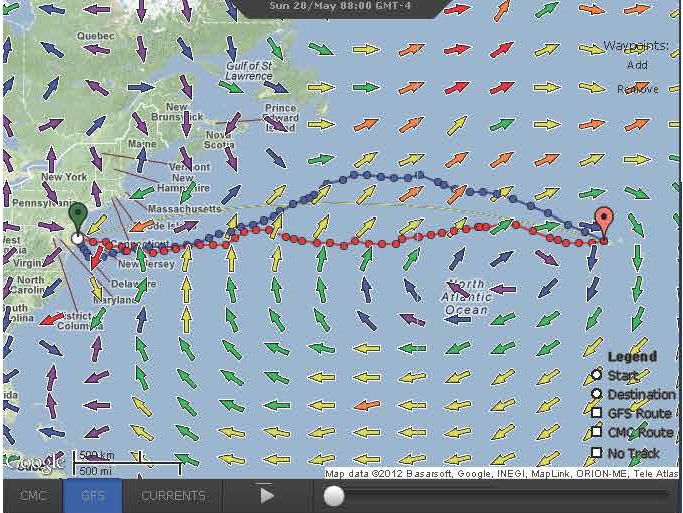
I had one additional interest, spawned in part by my previous work at Weathernews where I provided weather routing for ships. To the extent it is possible with weather forecasts (chaotic remember?) I want to optimize the route we take across oceans to minimize the time and minimize our exposure to adverse weather. Enter PredictWind. This website allows you to set up a route say, from Cape May to Horta, define the sailing performance of your boat using pre-defined “polars” for many production sailboats (a J/120 is one of them) or you can input your own polar chart specifying how your boat will perform for a multitude of wind directions and wind speeds. I’ve started with a J/120 polar table that I found onboard Shearwater and then reduced it by 15% since Chris & I would not be sailing the boat at 100% of its potential for days on end. 15% might even be optimistic, but I’ll collect some data and make adjustments in the future. With the route selected and boat performance selected you hit “Go” and PredictWind uses two modified global forecast models to design two optimized routes based on the model forecasts.

Route recommendations from PredictWind. Note how the two models basically agree for the first few days and then differ significantly afterwards.
I find this all fascinating. PredictWind even factors in the Gulf Stream current which has a big influence on the overall speed of a sailboat on passage between the US and Europe. That said, and in this case I speak from experience, having provided similar forecasts and routed big ships all over the world for several years, it is just a “forecast” and a “route suggestion”. Combine this with other weather information, look outside the boat at the weather around you and make an educated decision on a route that makes sense for you. Routing like this, though, can be really useful for avoiding storms or calms, both of which can have a huge impact on progress. PredictWind has a bunch of other weather related functions that are useful, but I’m particularly fond of the Weather Routing feature. I like this source of information because it A) factors in the performance of our boat which is quite different from most cruising boats (i.e., faster) and B) provides forecasts that have been review and edited by an experienced human, unlike typical raw model output GRIB files.
One final point. How, you might wonder, will we access the PredictWind website to get the route suggestions and forecasts? Fear not, as like the two previous sources of data, PredictWind has an email feature for Weather Routing. Just set up your preferences ahead of time on the website and then send an email with your current location and destination, and PredictWind will return an email with the suggested route and forecast in text format and Google Earth format. Exciting times we live in, no?
Here is our Cliff-note version of using a satellite phone for weather data, based on our research so far:
- Choose a satellite phone. Iridium or Inmarsat?
- Buy a SIM card
- Buy airtime minutes
- Subscribe to a satphone email service like XGate
- Buy a data compression device/router like Optimizer
- Send email requests to your favorite weather source, like Saildocs, NOAA, or something private like PredictWind
- Compare forecasts with local observations and experience
- Go sailing!
Leave a Reply