Stormy Weather

One of the things we get asked constantly by non-sailors and even some sailors is “what about storms?” or more specifically “what about hurricanes?” It hasn’t helped matters that for the first time in recorded history both the Eastern Pacific and the Atlantic had their first named storms of the year before June 1st. While true, here are some more facts that have steered us towards early July between a good time, maybe even the best time to cross the Atlantic.
Our route will take us along, or very near 38.5˚. This is well north of the tropical storm formation zone (south of 30˚N). In fact, it is possible to get quite reasonable insurance for crossing the Atlantic if you stay north of 31˚N. Not so, south of that line.
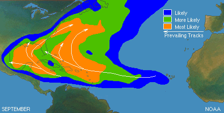
While July has a higher frequency of tropical storms, it is only slightly higher frequency than June, with June 1st being the first official day of hurricane season. August, September, and October have a much higher frequency of tropical storms than June & July. The peak of tropical storm development is mid-September.
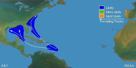
As you can see from the picture below, many tropical storms that form in July tend form or go west into the Gulf Mexico. The later in the season the more likely for the storm to track into Western Atlantic.
The real risk of a tropical storm or hurricane along our route in July, if one were to develop, is if the storm were to recurve north and then east. What could happen is the storm recurves and then heads east across North Atlantic. The key here, though, is that when this does happen the low-pressure center passes well north of our planned route. More likely along 45-50˚N. While this does bring about the possibility of strong following winds, it also means we can take evasive action by diving south towards the Atlantic High.
In fact, a greater risk during a North Atlantic crossing is confronting a winter gale, or mid-latitude low. A low-pressure system that tracked across the United States and on into the North Atlantic. These types of storms can be just as dangerous to a sailboat as a tropical storm, but they occur much more frequently during the winter months. Far less frequently during the summer, and when they do occur in the summer they track much further north, due to the Atlantic High also moving north during the summer.
Based on the above, July is actually a pretty good time to cross because it is a period that on average threads the needle between winter gales and tropical storms. As comfort to this conclusion Jimmy Cornell’s well regarded book “World Cruising Routes” identifies May-July as the best time to sail between the US East Coast and the Azores.
All that said, the goal will be to have a clear weather window of approximately 5 days from our departure. That will allow us to get across the Gulf Stream and position us along the edge of the Atlantic High where we can go, but tropical storms basically cannot. Once we pass north and then east of Bermuda any tropical storm development should with very high likelihood pass non-threateningly west and then north of us, with the distance increasing the further east we go.
P.S. If, like me, you were wondering. The “Perfect Storm” took place in late October.
P.P.S. Chris heads to the boat in 2 weeks. The clock is ticking and we are getting close!
2 comments
Leave a ReplyCancel reply
Sign up to receive blog updates


HI guys….quick “Dad” question…what is your route exactly or as exactly as you can get?
Short answer – Due east until we hit Europe. More literal than figurative.
Long answer – Up the Chesapeake to the C&D Canal. Down the Delaware to the Atlantic. The exit of Delaware Bay is about 38.5 degrees. Horta in the Azores is about 38.5 degrees. Lisbon is about 38.5 degrees. So we will sail more or less due east. Going a little north if the winds are light and a little south if the winds are strong. I’ve been running a weather routing model (PredictWind) twice a day for about 2 weeks now just to see how much variation there is in the routing recommendation and there isn’t much. We might go as far north as 42 north or as far south as 35 south, but probably not both on the same crossing. According to the NOAA iceberg advisory there are no bergs south of 43 north. We’ll keep watching that as the bergs may drift south over the next month so we will adjust accordingly. At this point I doubt we’ll go north of 40N, if at all, until we are east of 50W (roughly south of the easternmost point in Newfoundland) to make sure we aren’t berg dodging. Between the Delaware and Horta there isn’t much value in a great circle route because A) the icebergs in the Western Atlantic B) the Gulf Stream is favorable and stronger south of the GC course and C) as a I mentioned in the post, sailing closer to the center of the Atlantic High, but not so close there is no wind, gives you and out in case bad weather approaches. This plan will continue to evolve right up until we depart, when we’ll make a more specific route plan, then we’ll adjust daily as we get new weather info and route recommendations.